🔒 Architecture follows CIA Triad security framework—Confidentiality, Integrity, Availability—proven principles for operational control.
Optimized for minimal latency - speed is critical for tactical drone operations
Real-time drone operations demand minimal latency for tactical decision-making
2.25× FASTER - Critical advantage for real-time tactical operations
Operational relay under your unit's control - all recordings saved locally at HQ - access authorization managed by your unit, not service providers - complete control over who sees what (vs DJI: 65% with cloud dependency)
Video streaming server + VPN optimized for minimal latency - critical for real-time tactical decisions during drone operations (vs DJI: ≈ 450 ms)
Full Command & Control via ATAK UAS Tool plugin - pilot controls flight, waypoints, gimbal, and zoom - HQ shares Common Operating Picture (COP) across all ATAK users
Pilots use 4G/5G mobile networks in the field - HQ connects via high-speed internet or 5G - optimized for real-time video streaming performance
This plugin transforms ATAK into a complete drone control station with real-time video streaming via RTSP to our video streaming server - a key tactical advantage that DJI FlightHub cannot match.
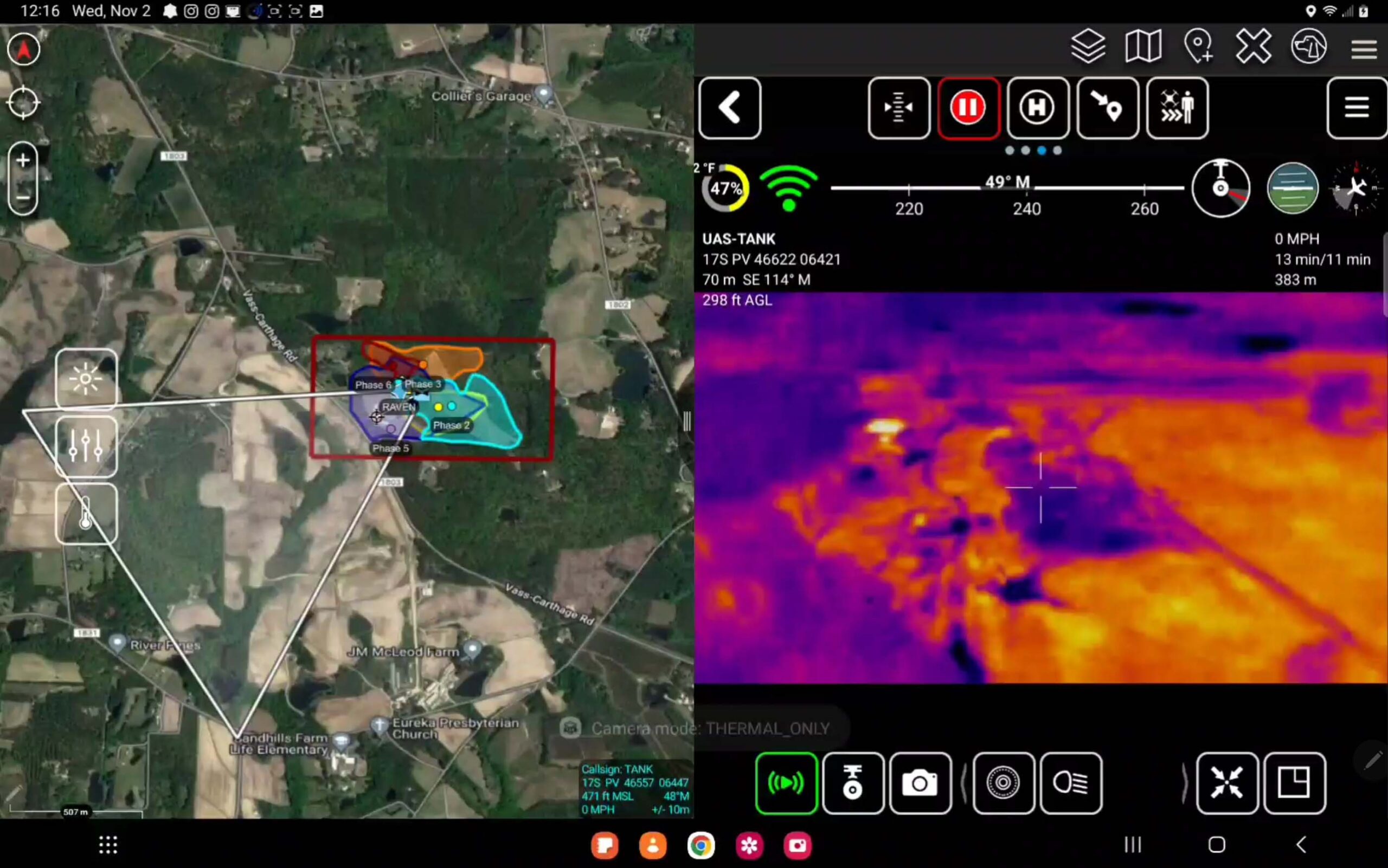
Draws drone Field of View (FOV) on ATAK tactical map in real-time, so all users know exactly which area is being observed
Operators can set waypoints, control gimbal, and zoom camera directly through ATAK interface with clear telemetry display
Drone position (PLI) and video are instantly shared to all ATAK users, enabling seamless coordination between different agencies
Transform your drone from 'flying camera' into tactical aerial intelligence (ISR) system directly integrated with command and control. ATAK UAS Tool is a Command & Control (C2) and ISR platform that fuses drones, ground teams, and intelligence data into a real-time Common Operational Picture (COP).
Supports AI/TensorFlow Object Detection integration via plugin or external processing systems (edge/onboard/server). Analyzes drone video feeds in real-time, displays detection results on tactical map, auto-marks and classifies targets, and sends alerts when specified objects appear (persons, vehicles, specific targets). ATAK serves as the central hub for display and command—not just a video viewer.
All units see the same picture on the same map. Real-time drone positions, ground teams, markers, and threat data. Instant data sharing across devices and agencies. ISR becomes teamwork, not isolated data viewing.
Plan missions at tactical level, not just waypoints. Define mission objectives, assign tasks to specific units, adjust plans and retask mid-mission based on real situations. Supports real-time commander decision-making.
Add mission-based safety layers. Create polygon geofences, define no-go/warning/restricted zones, use with terrain and threat data. ATAK geofence system complements drone safety systems and flight regulations.
Fuse data from multiple sources into one view: drone video, telemetry, field sensors, other intelligence. Creates more complete battlefield situational awareness than viewing a single drone alone.
Supports tactical alert and event logic. Alerts when entering defined zones, alerts for sensor or AI events, displays events on COP for immediate decision-making.
Collaborative intelligence gathering. Place markers and draw areas on map, send messages linked to actual locations. Pilots, analysts, and command staff work together in real-time.
Turn missions into lessons. Replay missions with key events, analyze decisions, use for training and SOP improvement.
Platform that grows with your mission. Add AI analytics, integrate new sensors, connect external systems, develop unit-specific logic. ATAK is not a closed system—it's the foundation of an expandable ISR/C2 system.
💡 ATAK UAS Tool transforms drones from simple remote-controlled cameras into tactical ISR sensors with shared maps, AI object detection, multi-unit collaboration, event alerts, and customizable mission logic — giving commanders real-time situational awareness and decision advantage.
Choose the solution optimized for speed and security: Video streaming server with VPN for ultra-low latency tactical operations
Choose 3rd Echelon ATAK Solution if your mission demands ultra-low latency video streaming, ATAK UAS Tool integration for full drone control, VPN security, and complete data sovereignty with local recording at HQ.
Choose DJI FlightHub Enterprise if your primary goal is routine infrastructure inspection, fleet battery management, and ease of use for non-technical operators.